|
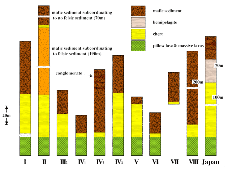
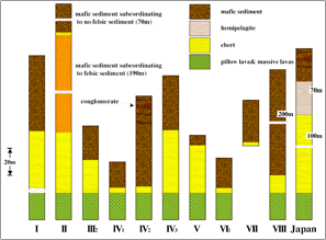 Figure 15: Lithostratigraphies of Duplexes I to VIII. Each lithostratigraphic unit
is composed of metabasite, chert, muddy chert and mafic sediment, in ascending
order. The metabasite consists of a pile of pillowed basalts with massive
basaltic flows and hyaloclastites. A reworked hyaloclastite with rough
surfaces and numerous metamorphic garnet megaporphyroblasts occurs at the
top. Mafic sediment with graded bedding covers the chert at the top. Muddy
chert occurs as a transitional sediment between the chert and the mafic
sediment. The reconstructed lithologies are comparable to the Phanerozoic
oceanic plate stratigraphy in Japan. Figure 15: Lithostratigraphies of Duplexes I to VIII. Each lithostratigraphic unit
is composed of metabasite, chert, muddy chert and mafic sediment, in ascending
order. The metabasite consists of a pile of pillowed basalts with massive
basaltic flows and hyaloclastites. A reworked hyaloclastite with rough
surfaces and numerous metamorphic garnet megaporphyroblasts occurs at the
top. Mafic sediment with graded bedding covers the chert at the top. Muddy
chert occurs as a transitional sediment between the chert and the mafic
sediment. The reconstructed lithologies are comparable to the Phanerozoic
oceanic plate stratigraphy in Japan.
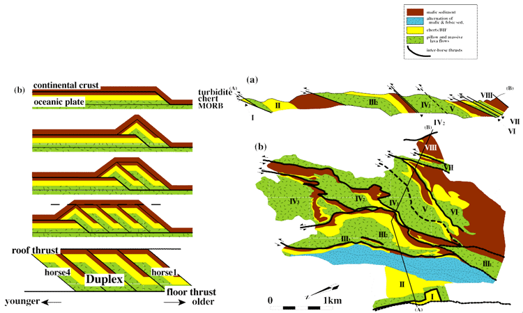
The stratigraphic top within each horse always faces southeastward, except
in a few strongly folded areas. Petrographic examination of chert indicates
that no continental or arc materials occur within the chert beds and underlying
pillow lava flows. Detrital materials start to appear in thin laminated
chert beds after the end of the major chert deposition, and become common
in the turbidite layers. The sequential change of sedimentary lithology,
from chert to turbidite, is common to all horses. The reconstructed lithostratigraphy
is remarkably similar to oceanic plate stratigraphy of circum-Pacific accretionary
complexes. The presence of duplexes indicates the geological structure
was formed by layer-parallel shortening, whereas evidence of oceanic plate
stratigraphy means lateral movement from pelagic ridge to continental margin.
The lines of evidence indicate that the Isua supracrustal belt is the oldest
accretionary complex. Komiya and others (1999) demonstrated that in the
Southern Unit, and possibly in the whole Isua supracrustal belt, an accretionary
complex formed through accretion of oceanic crust to the hangingwall, by
duplexing. A sequence of duplexing scenarios can be reconstructed as follows.
The structural bottom is Duplex I, and the top is Duplex VIII, as judged
by the southward polarity of duplexing. The younger horses develop downward;
therefore, the oldest duplex is VIII. Accretion proceeded from Duplex VIII
to I with time. Within a given Duplex, the southeastern horse is the oldest.
The similar lithostratigraphy within each horse suggests that the oceanic
crust segments subducted in the same area and period. The mode of formation
of the duplex structure throws light on the direction of the growth of
the accretionary prism and the subduction of oceanic lithosphere. The duplex
polarity is defined by the direction of convergence of faults, which divide
horses, and coincides with plate convergence. The southward convergent
morphology of the duplex structure is widespread over the mapped area,
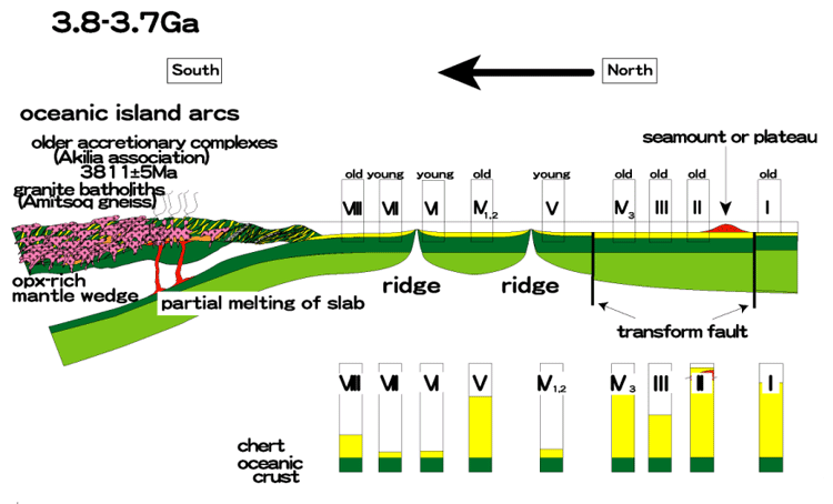
indicating that the Isua accretionary prism grew from south to north. A
paleogeographic reconstruction is shown in Figure 15 to illustrate the
sequential events of the accretionary prisms in the Southern Unit at about
3700-3800 Ma (Komiya et al., 1999). Geologic records preserved within turbidite
sediments also provide strong constraints on the type of active plate margin.
If they were formed along a large continental margin, they would be dominantly
quartzofeldspathic. If they were formed in intra-oceanic environments,
such as the present-day western Pacific domains, they would be dominantly
mafic in composition. The sedimentary petrology of the turbidite sequences
clearly indicates that the Isua accretionary complex was formed in the
latter environment, because mafic sediments are dominant in the turbidite
sequences. In the Archean, most orogenic belts were formed in intra-oceanic
island arcs, and then grew progressively through the collision-amalgamation
process.
|